[Source: East Suffolk Council]
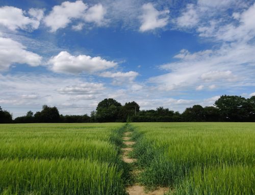
An annual scheme which creates essential spaces for wildlife will return this year, as part of East Suffolk Council’s commitment to the environment.
Launched in 2020, the Council’s ‘Pardon the weeds, we’re feeding the bees’ campaign returns for its third year with over 100 wild spaces where grass and wildflowers will be left to grow to help wildlife thrive.
These areas, which are large enough to provide an environmental benefit and do not present any safety issues for local communities, will be marked with our eye-catching yellow signs to make residents and visitors aware of the scheme.
Town and parish councils, supported by East Suffolk Norse, will monitor the conservation areas to remove litter and control any invasive plant species.
Cllr James Mallinder, East Suffolk’s cabinet member for the Environment said:
“We are committed to promoting environmental sustainability and ensuring responsible stewardship of our open spaces. The wild spaces are well received by local communities, and we are delighted to be bringing them back for another year to help wildlife to thrive and to benefit those living nearby.
“We are keen to encourage others to create wildlife spaces of their own and so this year, we are supporting town and parish councils to identify areas of their own land which could be used for conservation too. Participating town and parish councils will be able to order special signage for their wild spaces.”
East Suffolk Council has an ambitious environmental vision and since declaring a climate emergency in 2019, has expressed its intention to increase the number of wild spaces in the district, where a more conservation-based approach to cutting could promote biodiversity.
Town and parish councils are encouraged to contact East Suffolk Council to highlight any additional areas which could benefit from a possible change in how they are managed. Residents are asked to contact their town or parish council directly if they have any suggestions for new wild spaces.
Residents can also share photos of their local wildlife space on social media, tagging in East Suffolk Council and using #PardonTheWeeds.
The conservation areas are:
- Beccles St Michaels (churchyard)
- Highleas Close, Beccles (open space)
- Puddingmoor Slopes, Beccles (open space)
- St Mary Paddock, Beccles (open space)
- The Dell, Beccles (open space)
- St Marys Benhall (churchyard)
- Annis Hill Banks, Bungay (highway)
- Beccles Road, Bungay (highway)
- Cemetery, Bungay (cemetery)
- Elizabeth Bonholte Close, Bungay (open space)
- Old cemetery, Bungay (churchyard)
- St. Marys, Bungay (churchyard)
- Trinity, Bungay (churchyard)
- Carlton Park, Carlton Colville (open space)
- All Saints Easton (churchyard)
- Philip Avenue Felixstowe (open space)
- Brook Lane, Framlingham (highway)
- Castle Brook open space, Framlingham (open space)
- The Knoll, Framlingham (highway)
- Vyces Road, Framlingham (highway)
- Halesworth cemetery (cemetery)
- St. Marys, Halesworth (churchyard)
- All Saints Kesgrave (churchyard)
- Grange Farm Ashdale open space banked areas, Kesgrave (open space)
- Grange Farm Pergola Gardens, Kesgrave (open space)
- Grange Farm Ropes Drive underpasses, Kesgrave (open spaces)
- Grange Farm Through Jollys Open Space, Kesgrave (open space)
- St Margarets, Leiston (churchyard)
- Bloodmoor Road, Lowestoft (highway)
- Kirkley cemetery, Lowestoft (cemetery)
- Lowestoft cemetery (cemetery)
- Lowestoft Seafront Slopes (open space)
- Millennium Way, Lowestoft (highway)
- Normanston Drive/Peto Way Roundabout, Lowestoft (highway)
- Peto Way Banks, Lowestoft (highway)
- St Margarets, Lowestoft (churchyard)
- St Peter and St John, Lowestoft (churchyard)
- Old Churchyard, Melton (churchyard)
- St John The Baptist, Saxmundham (churchyard)
- St Marys Earl Soham, Soham (churchyard)
- Church/Hospital Green, Southwold (open space)
- Southwold St Edmunds (churchyard)
- St Peters and St Pauls Aldburgh, St Pauls. Peter (churchyard)
- St Martin & St Mary, Trimly St Martin (churchyard)
- St Marys, Ufford (churchyard)
- Ufford, Yarmouth Road/B1438 (highway)
- St Marys, Walpole (churchyard)
- St Peters, Wenhaston (churchyard)
- All Saints, Wickham Market (churchyard)
- Area behind the swimming pool, Woodbridge (open space)
- Cemetery, Woodbridge (cemetery)
- Collingwood Road, Woodbridge (highway)
- Hillyfields, Woodbridge (highway)
- Lime Kiln Quay, Woodbridge (highway)
- Seckford Hall Road, Woodbridge (highway)
- St Johns, Woodbridge (churchyard)
- St Marys, Woodbridge (churchyard)
- Through Duncans, Woodbridge (highway)
- Portland Crescent, Woodbridge (highway)
- Pepys Avenue, Worlingham (open space)
- Werels Loke, Worlingham (open space)
- St Nicholas, Wrentham (churchyard)
- Wrentham New Cemetery (cemetery)
- Wrentham Old Cemetery (cemetery)
- St Peters, Yoxford (churchyard)